
Make a donation
Animas topographic map
Click on the map to display elevation.
Make a donation
About this map
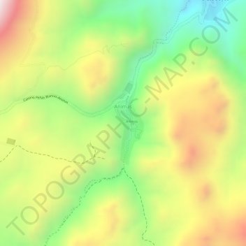
Name: Animas topographic map, elevation, terrain.
Location: Animas, Municipio Atocha, Sur Chichas, Potosí, Bolivia (-20.96706 -66.30864 -20.95772 -66.30488)
Average elevation: 4,280 m
Minimum elevation: 3,981 m
Maximum elevation: 4,583 m
Make a donation
Other topographic maps
Click on a map to view its topography, its elevation and its terrain.
Tupiza
Bolivia > Potosí > Sur Chichas
Se localiza en las coordenadas 21°26′15″S 65°42′57″O / -21.43750, -65.71583, a una altitud de 2.850 msnm.
Average elevation: 3,555 m
Municipio Atocha
Bolivia > Potosí > Sur Chichas
Posee hermosos paisajes con una topografía que muestra un terreno extraordinario, por la conformación de cerros y montañas geomorfológicos. Donde se tiene la presencia de viviendas de la época de la Colonia que acogieron al personal administrativo de los centros mineros de Animas, Siete Suyos, Santa Ana,…
Average elevation: 4,039 m
Make a donation
Tupiza
Bolivia > Potosí > Sur Chichas
Se localiza en las coordenadas 21°26′15″S 65°42′57″O / -21.43750, -65.71583, a una altitud de 2850 m s. n. m.
Average elevation: 3,555 m
Tupiza
Bolivia > Potosí > Sur Chichas
Se localiza en las coordenadas 21°26′15″S 65°42′57″O / -21.43750, -65.71583, a una altitud de 2850 m s. n. m.
Average elevation: 3,555 m