
Pulau Pagai Selatan topographic map
Interactive map
Click on the map to display elevation.
About this map
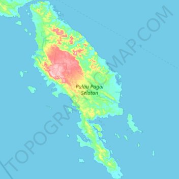
Name: Pulau Pagai Selatan topographic map, elevation, terrain.
Location: Pulau Pagai Selatan, West Sumatra, Indonesia (-3.34857 100.17622 -2.78324 100.47365)
Average elevation: 16 m
Minimum elevation: -1 m
Maximum elevation: 290 m
Other topographic maps
Click on a map to view its topography, its elevation and its terrain.
Pariangan
Indonesia > West Sumatra > Tanah Datar
Pariangan, Tanah Datar, West Sumatra, Sumatra, Indonesia
Average elevation: 1,040 m
Pulau Pagai Utara
Pulau Pagai Utara, West Sumatra, Indonesia
Average elevation: 28 m