
Thank you for supporting this site ❤️
Make a donation
Make a donation
Perry topographic map
Click on the map to display elevation.
Thank you for supporting this site ❤️
Make a donation
Make a donation
About this map
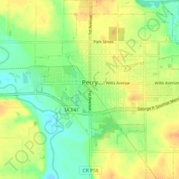
Name: Perry topographic map, elevation, terrain.
Location: Perry, Dallas County, Iowa, 50220, United States (41.81315 -94.12601 41.86032 -94.06739)
Average elevation: 293 m
Minimum elevation: 276 m
Maximum elevation: 309 m
Thank you for supporting this site ❤️
Make a donation
Make a donation
Other topographic maps
Click on a map to view its topography, its elevation and its terrain.