Geolocate

Java topographic map

Interactive map

Click on the map to display elevation.

About this map

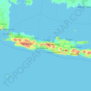
Name: Java topographic map, elevation, terrain.

Location: Java, Banjarnegara, Central Java, Indonesia (-8.78083 105.20947 -5.87545 114.60563)

Average elevation: 41 m

Minimum elevation: -2 m

Maximum elevation: 3,329 m

Other topographic maps

Click on a map to view its topography, its elevation and its terrain.

Sudimoro

Indonesia > Central Java > Sudimoro

Average elevation: 249 m

Boyolali

Indonesia > Central Java

Average elevation: 277 m

Pemalang

Indonesia > Central Java

Average elevation: 294 m

Gunung Lawu

Indonesia > Central Java > Gondosuli

Average elevation: 2,881 m

Mount Sumbing

Indonesia > Central Java

Average elevation: 2,841 m

Gunung Arjuna

Indonesia > Central Java > Kebumen

Average elevation: 282 m

Boyolali

Indonesia > Central Java > Boyolali

Average elevation: 403 m

Bandung

Indonesia > Central Java > Bandung

Average elevation: 194 m