
Make a donation
Blue Ridge Parkway topographic map
Click on the map to display elevation.
Make a donation
Blue Ridge Parkway
The parkway has been the most visited unit of the National Park System every year since 1946 except four (1949, 2013, 2016 and 2019). Land on either side of the road is owned and maintained by the National Park Service, and in many places parkway land is bordered by United States Forest Service property. There is no fee for using the parkway; however, commercial vehicles are prohibited without approval from the Park Service Headquarters, near Asheville, North Carolina. The roadway is not maintained in the winter, and sections that pass over especially high elevations and through tunnels are often impassable and therefore closed from late fall through early spring. Weather is extremely variable in the mountains, so conditions and closures often change rapidly. The speed limit is never higher than 45 mph (72 km/h) and is lower in some sections.
Make a donation
About this map
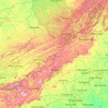
Name: Blue Ridge Parkway topographic map, elevation, terrain.
Average elevation: 504 m
Minimum elevation: 38 m
Maximum elevation: 1,983 m
Make a donation