
Cape Cod topographic map
Interactive map
Click on the map to display elevation.
About this map
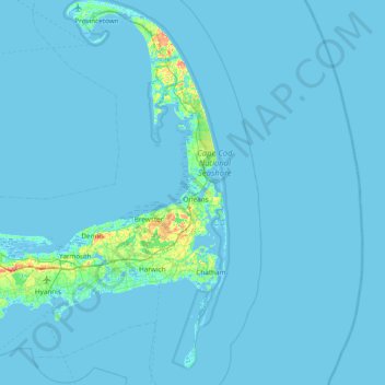
Name: Cape Cod topographic map, elevation, terrain.
Location: Cape Cod, Barnstable County, Massachusetts, United States (41.51497 -70.68798 42.08253 -69.92900)
Average elevation: 2 m
Minimum elevation: -6 m
Maximum elevation: 56 m
Cape Cod extends 65 miles (105 km) into the Atlantic Ocean, with a breadth of between 1–20 miles (1.6–32.2 km), and covers more than 400 miles (640 km) of shoreline. Its elevation ranges from 306 feet (93 m) at its highest point, at the top of Pine Hill, in the Bourne portion of Joint Base Cape Cod, down to sea level.
Other topographic maps
Click on a map to view its topography, its elevation and its terrain.
Marshfield
United States > Massachusetts > Plymouth County
Marshfield, Plymouth County, Massachusetts, 02050, United States
Average elevation: 14 m
Middleborough
United States > Massachusetts > Plymouth County
Middleborough, Plymouth County, Massachusetts, 02346, United States
Average elevation: 24 m
Wareham
United States > Massachusetts > Plymouth County
Wareham, Plymouth County, Massachusetts, United States
Average elevation: 12 m
Long Pond
United States > Massachusetts > Plymouth County > Lakeville
Long Pond, Lakeville, Plymouth County, Massachusetts, United States
Average elevation: 24 m
Plymouth
United States > Massachusetts > Plymouth County
Plymouth, Plymouth County, Massachusetts, United States
Average elevation: 24 m
Hingham
United States > Massachusetts > Plymouth County
Hingham, Plymouth County, Massachusetts, 02043, United States
Average elevation: 26 m
Brockton
United States > Massachusetts > Plymouth County
Brockton, Plymouth County, Massachusetts, United States
Average elevation: 45 m
Manomet Heights
United States > Massachusetts > Plymouth County > Plymouth
Manomet Heights, Plymouth, Plymouth County, Massachusetts, United States
Average elevation: 10 m
George Washington Forest
United States > Massachusetts > Plymouth County > Hingham > South Hingham
George Washington Forest, Huntley Road, South Hingham, Hingham, Plymouth County, Massachusetts, 02043, United States
Average elevation: 37 m
South Middleboro
United States > Massachusetts > Plymouth County > Middleborough
South Middleboro, Middleborough, Plymouth County, Massachusetts, United States
Average elevation: 34 m
Mercer Square
United States > Massachusetts > Plymouth County > Hanover
Mercer Square, Hanover, Plymouth County, Massachusetts, 02339, United States
Average elevation: 33 m
Marion
United States > Massachusetts > Plymouth County
Marion, Plymouth County, Massachusetts, 02738, United States
Average elevation: 6 m
Ocean Bluff
United States > Massachusetts > Plymouth County > Marshfield
Ocean Bluff, Marshfield, Plymouth County, Massachusetts, United States
Average elevation: 3 m
West Wareham
United States > Massachusetts > Plymouth County > Wareham
West Wareham, Wareham, Plymouth County, Massachusetts, 02576, United States
Average elevation: 21 m
Indian Pond
United States > Massachusetts > Plymouth County > Kingston
Indian Pond, Kingston, Plymouth County, Massachusetts, United States
Average elevation: 42 m
Marshfield Hills
United States > Massachusetts > Plymouth County > Marshfield
Marshfield Hills, Marshfield, Plymouth County, Massachusetts, 02050, United States
Average elevation: 29 m
D.W. Field Park
United States > Massachusetts > Plymouth County > Brockton
D.W. Field Park, Brockton, Plymouth County, Massachusetts, United States
Average elevation: 56 m
Kent Park
United States > Massachusetts > Plymouth County > Marshfield
Kent Park, Marshfield, Plymouth County, Massachusetts, 02050, United States
Average elevation: 13 m
Manomet Beach
United States > Massachusetts > Plymouth County > Plymouth
Manomet Beach, Plymouth, Plymouth County, Massachusetts, United States
Average elevation: 7 m
Lakeville
United States > Massachusetts > Plymouth County
Lakeville, Plymouth County, Massachusetts, United States
Average elevation: 24 m
Duxbury
United States > Massachusetts > Plymouth County
Duxbury, Plymouth County, Massachusetts, United States
Average elevation: 13 m
Minot
United States > Massachusetts > Plymouth County > Scituate
Minot, Scituate, Plymouth County, Massachusetts, 02060, United States
Average elevation: 2 m
Onset
United States > Massachusetts > Plymouth County > Wareham
Onset, Wareham, Plymouth County, Massachusetts, 02538, United States
Average elevation: 5 m
The Green
United States > Massachusetts > Plymouth County > Middleborough
The Green, Middleborough, Plymouth County, Massachusetts, 02346, United States
Average elevation: 30 m
Kingston
United States > Massachusetts > Plymouth County
Kingston, Plymouth County, Massachusetts, 02364, United States
Average elevation: 28 m
Scituate Center
United States > Massachusetts > Plymouth County > Scituate
Scituate Center, Scituate, Plymouth County, Massachusetts, 02066, United States
Average elevation: 20 m
Spectacle Pond
United States > Massachusetts > Plymouth County > Wareham
Spectacle Pond, Wareham, Plymouth County, Massachusetts, United States
Average elevation: 8 m
Hingham Center
United States > Massachusetts > Plymouth County > Hingham
Hingham Center, Hingham, Plymouth County, Massachusetts, 02043, United States
Average elevation: 17 m
Norwell
United States > Massachusetts > Plymouth County
Norwell, Plymouth County, Massachusetts, 02061, United States
Average elevation: 30 m
Hanson
United States > Massachusetts > Plymouth County
Hanson, Plymouth County, Massachusetts, United States
Average elevation: 26 m
Hanover
United States > Massachusetts > Plymouth County
Hanover, Plymouth County, Massachusetts, United States
Average elevation: 23 m
West Bridgewater
United States > Massachusetts > Plymouth County
West Bridgewater, Plymouth County, Massachusetts, 02379, United States
Average elevation: 26 m
Cranberry Village
United States > Massachusetts > Plymouth County > Carver
Cranberry Village, Carver, Plymouth County, Massachusetts, 02506, United States
Average elevation: 30 m
North Hanson
United States > Massachusetts > Plymouth County > Hanson
North Hanson, Hanson, Plymouth County, Massachusetts, 02333, United States
Average elevation: 28 m
Five Corners
United States > Massachusetts > Plymouth County > Wareham
Five Corners, Wareham, Plymouth County, Massachusetts, 02576, United States
Average elevation: 23 m
Camp Ousamequin
United States > Massachusetts > Plymouth County > Halifax
Camp Ousamequin, Halifax, Plymouth County, Massachusetts, 02350, United States
Average elevation: 20 m
Ellisville
United States > Massachusetts > Plymouth County > Plymouth
Ellisville, Plymouth, Plymouth County, Massachusetts, United States
Average elevation: 17 m
Cole Mill
United States > Massachusetts > Plymouth County > Carver
Cole Mill, Carver, Plymouth County, Massachusetts, 02367, United States
Average elevation: 34 m
South Pond
United States > Massachusetts > Plymouth County > Plymouth
South Pond, Plymouth, Plymouth County, Massachusetts, 02360, United States
Average elevation: 38 m
East Wareham
United States > Massachusetts > Plymouth County > Wareham
East Wareham, Wareham, Plymouth County, Massachusetts, 02538, United States
Average elevation: 7 m
East Carver
United States > Massachusetts > Plymouth County > Plymouth
East Carver, Plymouth, Plymouth County, Massachusetts, 02330, United States
Average elevation: 43 m
Scituate
United States > Massachusetts > Plymouth County
Scituate, Plymouth County, Massachusetts, United States
Average elevation: 13 m
Huckleberry Corner
United States > Massachusetts > Plymouth County > Carver
Huckleberry Corner, Carver, Plymouth County, Massachusetts, 02506, United States
Average elevation: 26 m
Nameloc Heights
United States > Massachusetts > Plymouth County > Plymouth
Nameloc Heights, Plymouth, Plymouth County, Massachusetts, 02562, United States
Average elevation: 19 m
Tremont
United States > Massachusetts > Plymouth County > Wareham
Tremont, Wareham, Plymouth County, Massachusetts, 02576, United States
Average elevation: 22 m
Sampson Pond
United States > Massachusetts > Plymouth County > Carver > South Carver
Sampson Pond, South Carver, Carver, Plymouth County, Massachusetts, United States
Average elevation: 28 m
Wenham
United States > Massachusetts > Plymouth County > Carver
Wenham, Carver, Plymouth County, Massachusetts, 02330, United States
Average elevation: 38 m
Old Spain
United States > Massachusetts > Plymouth County > Hingham
Old Spain, Hingham, Plymouth County, Massachusetts, 02043, United States
Average elevation: 11 m
Pembroke
United States > Massachusetts > Plymouth County
Pembroke, Plymouth County, Massachusetts, 02359, United States
Average elevation: 24 m
Plympton
United States > Massachusetts > Plymouth County
Plympton, Plymouth County, Massachusetts, 02367, United States
Average elevation: 24 m