
Maulny topographic map
Interactive map
Click on the map to display elevation.
About this map
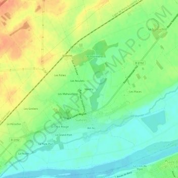
Name: Maulny topographic map, elevation, terrain.
Average elevation: 87 m
Minimum elevation: 68 m
Maximum elevation: 111 m
Other topographic maps
Click on a map to view its topography, its elevation and its terrain.
Le Bourg
France > Centre-Val de Loire > Loir-et-Cher > Suèvres
Le Bourg, Suèvres, Blois, Loir-et-Cher, Centre-Val de Loire, France métropolitaine, 41500, France
Average elevation: 85 m