
Thank you for supporting this site ❤️
Make a donation
Make a donation
Bjelkerud topographic map
Click on the map to display elevation.
Thank you for supporting this site ❤️
Make a donation
Make a donation
About this map
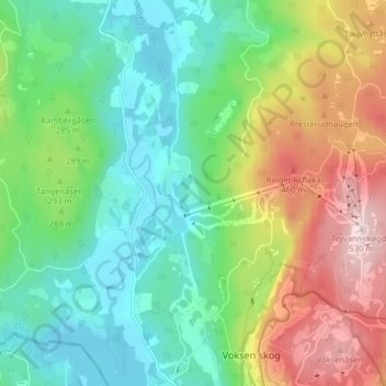
Name: Bjelkerud topographic map, elevation, terrain.
Location: Bjelkerud, Marka, Oslo, 0763, Norge (59.97229 10.61375 60.01229 10.65375)
Average elevation: 276 m
Minimum elevation: 140 m
Maximum elevation: 534 m
Thank you for supporting this site ❤️
Make a donation
Make a donation
Other topographic maps
Click on a map to view its topography, its elevation and its terrain.