
Haardt topographic map
Interactive map
Click on the map to display elevation.
About this map
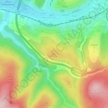
Name: Haardt topographic map, elevation, terrain.
Location: Haardt, Suhl, Thüringen, 98529, Deutschland (50.59095 10.65814 50.59105 10.65824)
Average elevation: 497 m
Minimum elevation: 386 m
Maximum elevation: 648 m
Other topographic maps
Click on a map to view its topography, its elevation and its terrain.
Schneekopf
Deutschland > Thüringen > Suhl
Schneekopf, Suhl, Thüringen, 98528, Deutschland
Average elevation: 855 m
Wichtshausen
Deutschland > Thüringen > Suhl
Wichtshausen, Suhl, Thüringen, 98530, Deutschland
Average elevation: 446 m
Albrechts
Deutschland > Thüringen > Suhl
Albrechts, Suhl, Thüringen, 98529, Deutschland
Average elevation: 491 m
Vesser
Deutschland > Thüringen > Suhl
Vesser, Suhl, Thüringen, 98528, Deutschland
Average elevation: 718 m
Großer Beerberg
Deutschland > Thüringen > Suhl
Großer Beerberg, Suhl, Thüringen, 98528, Deutschland
Average elevation: 853 m
Domberg
Deutschland > Thüringen > Suhl
Domberg, Suhl, Thüringen, 98527, Deutschland
Average elevation: 519 m
Lauter
Deutschland > Thüringen > Suhl > Lauter
Lauter, Suhl, Thüringen, 98527, Deutschland
Average elevation: 569 m
Schmücke
Deutschland > Thüringen > Suhl
Schmücke, Gehlberg, Suhl, Thüringen, 98528, Deutschland
Average elevation: 817 m
Gehlberg
Deutschland > Thüringen > Suhl
Gehlberg, Suhl, Thüringen, Deutschland
Average elevation: 771 m
Heinrichs
Deutschland > Thüringen > Suhl
Heinrichs, Suhl, Thüringen, 98529, Deutschland
Average elevation: 486 m
Heidersbach
Deutschland > Thüringen > Suhl > Heidersbach
Heidersbach, Suhl, Thüringen, 98528, Deutschland
Average elevation: 645 m