
Agrihan topographic map
Interactive map
Click on the map to display elevation.
About this map
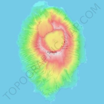
Name: Agrihan topographic map, elevation, terrain.
Average elevation: 178 m
Minimum elevation: -1 m
Maximum elevation: 953 m
Other topographic maps
Click on a map to view its topography, its elevation and its terrain.
Pagan Island
United States > Northern Mariana Islands > Northern Islands Municipality > Shomushon
Pagan Island, Shomushon, Northern Islands Municipality, Northern Mariana Islands, United States
Average elevation: 35 m
Sarigan
United States > Northern Mariana Islands > Northern Islands Municipality
Sarigan, Northern Islands Municipality, Northern Mariana Islands, United States
Average elevation: 89 m