
Thank you for supporting this site ❤️
Make a donation
Make a donation
Reboredo topographic map
Click on the map to display elevation.
Thank you for supporting this site ❤️
Make a donation
Make a donation
About this map
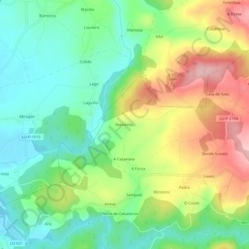
Name: Reboredo topographic map, elevation, terrain.
Location: Reboredo, Bande, Láncara, Sarria, Lugo, Galicia, 27367, España (42.86450 -7.43300 42.90450 -7.39300)
Average elevation: 440 m
Minimum elevation: 368 m
Maximum elevation: 554 m
Thank you for supporting this site ❤️
Make a donation
Make a donation
Other topographic maps
Click on a map to view its topography, its elevation and its terrain.