Geolocate

舒城县 topographic map

Interactive map

Click on the map to display elevation.

About this map

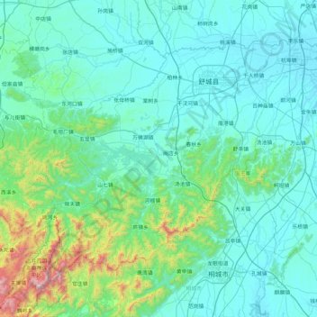
Name: 舒城县 topographic map, elevation, terrain.

Location: 舒城县, 六安市, 安徽省, 231300, 中国 (31.02135 116.42578 31.56375 117.24951)

Average elevation: 172 m

Minimum elevation: 4 m

Maximum elevation: 1,479 m

舒城县地势由西南向东北倾斜,作阶梯状下降。最高点柱突尖(即猪头尖),海拔1539米,最低处为杭埠镇胜合村民组,海拔6.8 米。地貌大体分山地、丘岗、平原和水域四种类型组合。

Wikipedia (CC-BY-SA 3.0)

Other topographic maps

Click on a map to view its topography, its elevation and its terrain.

霍山县

中国 > 安徽省 > 六安市

霍山县, 六安市, 安徽省, 中国

Average elevation: 429 m

汤家汇镇

中国 > 安徽省 > 六安市

汤家汇镇, 六安市, 安徽省, 中国

Average elevation: 308 m

叶集区

中国 > 安徽省 > 六安市

叶集区, 六安市, 安徽省, 中国

Average elevation: 84 m

大河沿

中国 > 安徽省 > 六安市

大河沿, 六安市, 安徽省, 中国

Average elevation: 120 m

裕安区

中国 > 安徽省 > 六安市

裕安区, 六安市, 安徽省, 中国

Average elevation: 63 m

霍邱县

中国 > 安徽省 > 六安市

霍邱县, 六安市, 安徽省, 中国

Average elevation: 34 m

金寨县

中国 > 安徽省 > 六安市

金寨县, 六安市, 安徽省, 中国

Average elevation: 407 m

三湾

中国 > 安徽省 > 六安市

三湾, 六安市, 安徽省, 中国

Average elevation: 76 m

兴丰

中国 > 安徽省 > 六安市 > 兴丰

兴丰, 六安市, 安徽省, 中国

Average elevation: 12 m