Geolocate

Diamond topographic map

Interactive map

Click on the map to display elevation.

About this map

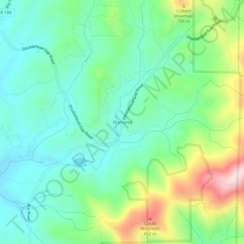
Name: Diamond topographic map, elevation, terrain.

Location: Diamond, Gilmer County, Georgia, United States (34.65425 -84.29603 34.69425 -84.25603)

Average elevation: 644 m

Minimum elevation: 526 m

Maximum elevation: 926 m

Other topographic maps

Click on a map to view its topography, its elevation and its terrain.

Ellijay

United States > Georgia > Gilmer County

Ellijay, Gilmer County, Georgia, 30540, United States

Average elevation: 424 m

East Ellijay

United States > Georgia > Gilmer County

East Ellijay, Gilmer County, Georgia, United States

Average elevation: 440 m

Chopped Oak

United States > Georgia > Gilmer County

Chopped Oak, Gilmer County, Georgia, United States

Average elevation: 560 m

Cherry Log

United States > Georgia > Gilmer County

Cherry Log, Gilmer County, Georgia, United States

Average elevation: 522 m

Carters Lake

United States > Georgia > Gilmer County

Carters Lake, Gilmer County, Georgia, United States

Average elevation: 370 m

Burnett

United States > Georgia > Gilmer County

Burnett, Gilmer County, Georgia, United States

Average elevation: 578 m