
Thank you for supporting this site ❤️
Make a donation
Make a donation
Huanuni topographic map
Click on the map to display elevation.
Thank you for supporting this site ❤️
Make a donation
Make a donation
About this map
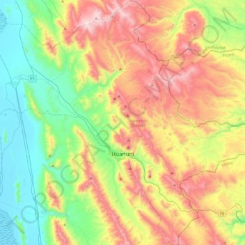
Name: Huanuni topographic map, elevation, terrain.
Location: Huanuni, Pantaleón Dalence, Oruro, Bolivia (-18.43328 -66.91167 -18.03749 -66.52834)
Average elevation: 4,143 m
Minimum elevation: 3,691 m
Maximum elevation: 4,831 m
Thank you for supporting this site ❤️
Make a donation
Make a donation
Other topographic maps
Click on a map to view its topography, its elevation and its terrain.