
Sonne topographic map
Interactive map
Click on the map to display elevation.
About this map
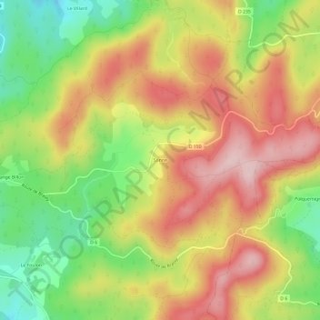
Name: Sonne topographic map, elevation, terrain.
Average elevation: 515 m
Minimum elevation: 383 m
Maximum elevation: 635 m
Other topographic maps
Click on a map to view its topography, its elevation and its terrain.
Le Foulon
France > Bourgogne-Franche-Comté > Nièvre > Lormes
Le Foulon, Lormes, Château-Chinon (Ville), Nièvre, Bourgogne-Franche-Comté, France métropolitaine, 58140, France
Average elevation: 444 m
Sommée
France > Bourgogne-Franche-Comté > Nièvre > Lormes
Sommée, Lormes, Château-Chinon (Ville), Nièvre, Bourgogne-Franche-Comté, France métropolitaine, 58140, France
Average elevation: 464 m
La Brinjame
France > Bourgogne-Franche-Comté > Nièvre > Lormes
La Brinjame, Lormes, Château-Chinon (Ville), Nièvre, Bourgogne-Franche-Comté, France métropolitaine, 58140, France
Average elevation: 350 m
L'Auxois
France > Bourgogne-Franche-Comté > Nièvre > Lormes
L'Auxois, Lormes, Château-Chinon (Ville), Nièvre, Bourgogne-Franche-Comté, France métropolitaine, 58140, France
Average elevation: 298 m