
Thank you for supporting this site ❤️
Make a donation
Make a donation
Granges-Sainte-Marie topographic map
Click on the map to display elevation.
Thank you for supporting this site ❤️
Make a donation
Make a donation
About this map
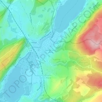
Name: Granges-Sainte-Marie topographic map, elevation, terrain.
Average elevation: 908 m
Minimum elevation: 847 m
Maximum elevation: 1,063 m
Thank you for supporting this site ❤️
Make a donation
Make a donation
Other topographic maps
Click on a map to view its topography, its elevation and its terrain.
Lac de Remoray
France > Bourgogne-Franche-Comté > Doubs > Labergement-Sainte-Marie
Le lac de Remoray est situé sur le territoire des communes de Remoray-Boujeons et de Labergement-Sainte-Marie. C'est un lac d'altitude (850 m) en plein cœur des hautes-chaînes du massif du Jura. Il occupe un site de 95 hectares.
Average elevation: 887 m
25160
France > Bourgogne-Franche-Comté > Doubs > Labergement-Sainte-Marie > Le Montrinsans
Average elevation: 889 m