
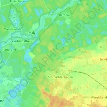
Schmachtenhagen topographic map
Interactive map
Click on the map to display elevation.
About this map
Name: Schmachtenhagen topographic map, elevation, terrain.
Average elevation: 43 m
Minimum elevation: 31 m
Maximum elevation: 62 m
Other topographic maps
Click on a map to view its topography, its elevation and its terrain.
Malz
Deutschland > Brandenburg > Oberhavel > Oranienburg
Malz, Oranienburg, Oberhavel, Brandenburg, Deutschland
Average elevation: 40 m
Bernöwe
Deutschland > Brandenburg > Oberhavel > Oranienburg
Bernöwe, Oranienburg, Oberhavel, Brandenburg, Deutschland
Average elevation: 41 m
Glashütte
Deutschland > Brandenburg > Oberhavel > Oranienburg > Fichtengrund
Glashütte, Fichtengrund, Oranienburg, Oberhavel, Brandenburg, 16515, Deutschland
Average elevation: 38 m
Germendorf
Deutschland > Brandenburg > Oberhavel > Oranienburg
Germendorf, Oranienburg, Oberhavel, Brandenburg, Deutschland
Average elevation: 41 m