
Thank you for supporting this site ❤️
Make a donation
Make a donation
Ruijin topographic map
Click on the map to display elevation.
Thank you for supporting this site ❤️
Make a donation
Make a donation
About this map
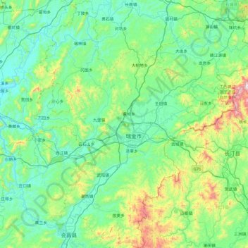
Name: Ruijin topographic map, elevation, terrain.
Location: Ruijin, Ganzhou, Jiangxi, 342500, China (25.54895 115.68608 26.29630 116.36528)
Average elevation: 335 m
Minimum elevation: 123 m
Maximum elevation: 1,324 m
Thank you for supporting this site ❤️
Make a donation
Make a donation
Other topographic maps
Click on a map to view its topography, its elevation and its terrain.
Thank you for supporting this site ❤️
Make a donation
Make a donation
Thank you for supporting this site ❤️
Make a donation
Make a donation
Thank you for supporting this site ❤️
Make a donation
Make a donation
Thank you for supporting this site ❤️
Make a donation
Make a donation
Thank you for supporting this site ❤️
Make a donation
Make a donation
Jingdezhen
Jingdezhen is situated in the north-east of Jiangxi and borders on Anhui; the city center area is located in the north-east of the Poyang Lake Plain. Its area is 5,256 km2 (2,029 sq mi).[10] The highest point is 1,618 m (5,308 ft), with plains on the southern part having an average altitude of 200 m (660 ft).
Average elevation: 100 m
Thank you for supporting this site ❤️
Make a donation
Make a donation
Thank you for supporting this site ❤️
Make a donation
Make a donation
Thank you for supporting this site ❤️
Make a donation
Make a donation