
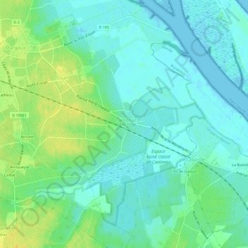
Le Bourg topographic map
Interactive map
Click on the map to display elevation.
About this map
Name: Le Bourg topographic map, elevation, terrain.
Average elevation: 8 m
Minimum elevation: -2 m
Maximum elevation: 22 m
Other topographic maps
Click on a map to view its topography, its elevation and its terrain.
Hameau de Doumens
France > Nouvelle-Aquitaine > Gironde > Margaux-Cantenac
Hameau de Doumens, Margaux, Margaux-Cantenac, Lesparre-Médoc, Gironde, Nouvelle-Aquitaine, France métropolitaine, 33460, France
Average elevation: 14 m
Margaux
France > Nouvelle-Aquitaine > Gironde > Margaux-Cantenac > Margaux
Margaux, Margaux-Cantenac, Lesparre-Médoc, Gironde, Nouvelle-Aquitaine, France métropolitaine, 33460, France
Average elevation: 12 m
Cantenac
France > Nouvelle-Aquitaine > Gironde > Margaux-Cantenac
Cantenac, Margaux-Cantenac, Lesparre-Médoc, Gironde, Nouvelle-Aquitaine, France métropolitaine, 33460, France
Average elevation: 11 m
Cantenac
France > Nouvelle-Aquitaine > Gironde > Margaux-Cantenac > Cantenac
Cantenac, Margaux-Cantenac, Lesparre-Médoc, Gironde, Nouvelle-Aquitaine, France métropolitaine, 33460, France
Average elevation: 8 m
Margaux
France > Nouvelle-Aquitaine > Gironde > Margaux-Cantenac
Margaux, Margaux-Cantenac, Lesparre-Médoc, Gironde, Nouvelle-Aquitaine, France métropolitaine, 33460, France
Average elevation: 9 m