
La Velle sous Moux topographic map
Interactive map
Click on the map to display elevation.
About this map
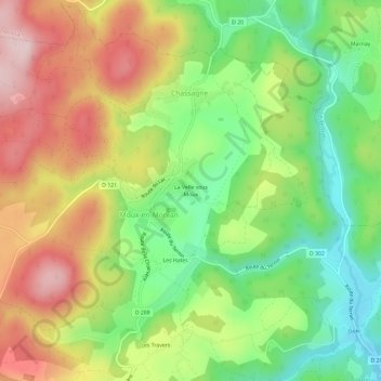
Name: La Velle sous Moux topographic map, elevation, terrain.
Average elevation: 537 m
Minimum elevation: 396 m
Maximum elevation: 703 m
Other topographic maps
Click on a map to view its topography, its elevation and its terrain.
Les Chaluts
France > Bourgogne-Franche-Comté > Nièvre > Chassagne > La Velle sous Moux
Les Chaluts, La Velle sous Moux, Chassagne, Moux-en-Morvan, Château-Chinon (Ville), Nièvre, Bourgogne-Franche-Comté, France métropolitaine, 58230, France
Average elevation: 522 m