
Thank you for supporting this site ❤️
Make a donation
Make a donation
Selising topographic map
Click on the map to display elevation.
Thank you for supporting this site ❤️
Make a donation
Make a donation
About this map
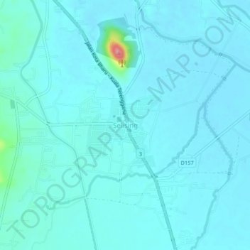
Name: Selising topographic map, elevation, terrain.
Location: Selising, Pasir Puteh, Kelantan, 16810, Malaysia (5.87492 102.31380 5.91492 102.35380)
Average elevation: 12 m
Minimum elevation: 2 m
Maximum elevation: 110 m
Thank you for supporting this site ❤️
Make a donation
Make a donation
Other topographic maps
Click on a map to view its topography, its elevation and its terrain.
Thank you for supporting this site ❤️
Make a donation
Make a donation
Thank you for supporting this site ❤️
Make a donation
Make a donation