
Make a donation
Magdalena topographic map
Click on the map to display elevation.
Make a donation
Magdalena
The Department of Magdalena, because of its terrain, and proximity to the sea has an unstable weather. Its Climate is mainly dictated by its global positioning, and because the department of Magdalena is located on the Intertropical Convergence Zone it possess an inter-tropical climate. Temperature in the department is affected by ocean currents, precipitation and atmospheric pressure, it mainly has a hot temperatures with high humidity, but temperatures vary as altitude raises.
Make a donation
About this map
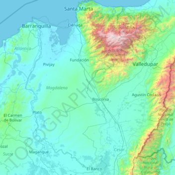
Name: Magdalena topographic map, elevation, terrain.
Location: Magdalena, Colombia (8.91711 -74.94559 11.34907 -73.54198)
Average elevation: 407 m
Minimum elevation: -1 m
Maximum elevation: 5,519 m
Make a donation
Other topographic maps
Click on a map to view its topography, its elevation and its terrain.
Bogota
The city is located in the center of Colombia, on a high plateau known as the Bogotá savanna, part of the Altiplano Cundiboyacense located in the Eastern Cordillera of the Andes. Its altitude averages 2,640 meters (8,660 ft) above sea level. Subdivided into 20 localities, Bogotá has an area of 1,587 square…
Average elevation: 2,735 m
Medellín
Colombia > Antioquia > Medellín
Medellín has 16 comunas (districts), 5 corregimientos (townships), and 271 barrios (neighborhoods). The metropolitan area of Medellín lies within the Aburrá valley at an elevation of 1,500 metres (4,900 feet) above sea level and is bisected by the Medellín River (also called Porce), which flows northward.…
Average elevation: 2,098 m
Make a donation
Andes
Andes is a municipality and town in the Antioquia Department, Colombia. Part of the sub-region of Southwestern Antioquia, it is located on the western Colombian Andes mountain range. Andes was founded on 13 March 1852 by Pedro Antonio Restrepo Escobar. Its elevation is 1,360 metres above sea level with an…
Average elevation: 1,559 m
Sierra Nevada de Santa Marta
Colombia > Magdalena > Aracataca
The Sierra Nevada de Santa Marta (English: Snow-Covered Mountain Range of Saint Martha) is an isolated mountain range in northern Colombia, separate from the Andes range that runs through the north of the country. Reaching an elevation of 5,700 m (18,700 ft) just 42 km (26 mi) from the Caribbean coast, the…
Average elevation: 5,013 m
Manizales
Manizales is the capital city of one of the smallest Colombian departments. The city is described as having an "abrupt topography", and lies on the Colombian Central Mountain Range (part of the longest continental mountain range, the Andes), with a great deal of ridgelines and steep slopes, which, combined…
Average elevation: 2,010 m
Make a donation
Andes
Andes is a municipality and town in the Antioquia Department, Colombia. Part of the sub-region of Southwestern Antioquia, it is located on the western Colombian Andes mountain range. Andes was founded on 13 March 1852 by Pedro Antonio Restrepo Escobar. Its elevation is 1,360 metres above sea level with an…
Average elevation: 1,559 m
Volcán Nevado del Ruiz
The summit of the volcano has steep slopes inclining from 20 to 30 degrees. At lower elevations, the slopes become less steep; their inclination is about 10 degrees. From there on, foothills stretch almost to the edge of the Magdalena River, north of the volcano and the Cauca River to the west. On the two…
Average elevation: 5,119 m
Make a donation
Make a donation
Rionegro
Colombia > Antioquia > Rionegro
The city of Rionegro is located at 6°9′18″N 75°22′48″W / 6.15500°N 75.38000°W / 6.15500; -75.38000, at an average elevation of 2,125 metres (6,972 ft) above sea level. The average annual precipitation varies between 1,800 and 2,500 millimetres (71 and 98 in) with an average temperature of…
Average elevation: 2,232 m
Cajicá
Cajicá is a municipality and town of Colombia in the department of Cundinamarca, 39 km (24 mi) north of the capital Bogotá. It is located in the Central Savanna Province, being the third most populous municipality in the province after Zipaquirá and Chía. It is bordered by the municipalities of Zipaquirá…
Average elevation: 2,611 m
Make a donation
Cerro de Monserrate
Colombia > Bogota, Capital District
Both Monserrate and its neighbor Guadalupe Hill are icons of Bogota's cityscape. The hill is a tourist attraction with access by funicular or cable car (both of which charge a fee) or the pilgrimage hiking trail (free). The hiking path is 2.4 km (1.5 mi), where you can walk up the steep hill on a journey that…
Average elevation: 2,884 m
Make a donation
Make a donation
Támesis
Colombia > Antioquia > Támesis
Támesis is a town and municipality in the Colombian department of Antioquia. Part of the subregion of Southwestern Antioquia. Located at an elevation of 1,638 m (5,374 ft) above sea level, it was established in 1858. The local economy is based on agriculture.
Average elevation: 1,718 m
Make a donation
Rionegro
Colombia > Antioquia > Rionegro
The city of Rionegro is located at 6°9′18″N 75°22′48″W / 6.15500°N 75.38000°W / 6.15500; -75.38000, at an average elevation of 2,125 metres (6,972 ft) above sea level. The average annual precipitation varies between 1,800 and 2,500 millimetres (71 and 98 in) with an average temperature of…
Average elevation: 2,232 m
Andes
Andes is a municipality and town in the Antioquia Department, Colombia. Part of the sub-region of Southwestern Antioquia, it is located on the western Colombian Andes mountain range. Andes was founded on 13 March 1852 by Pedro Antonio Restrepo Escobar. Its elevation is 1,360 metres above sea level with an…
Average elevation: 1,559 m
Make a donation
Ciénaga La Popa
Colombia > Antioquia > Yondó > San Miguel del Tigre > El Tigre
Average elevation: 72 m
Make a donation
Caucasia
Colombia > Antioquia > Caucasia
The municipality of Caucasia is located at the northern department of Antioquia, on the border with the department of Córdoba and the subregion of Bajo Cauca Antioquia. It lies at an altitude of 150 m (490 ft) above sea level. Its territory is a flat area with small ridges in the north and west and south. It…
Average elevation: 63 m
Rionegro
Colombia > Antioquia > Rionegro
The city of Rionegro is located at 6°9′18″N 75°22′48″W / 6.15500°N 75.38000°W / 6.15500; -75.38000, at an average elevation of 2,125 metres (6,972 ft) above sea level. The average annual precipitation varies between 1,800 and 2,500 millimetres (71 and 98 in) with an average temperature of…
Average elevation: 2,232 m
Make a donation
Make a donation
Tunja
Tunja has a population of 172,548 inhabitants according to the 2018 Census. 0.1% of the city is indigenous, 0.4% is black, and 99.5% is white and Mestizo. It is located in central Colombia, at an elevation ranging from approximately 2,700 metres (8,900 ft) to 2,900 metres (9,500 ft). The city centre is at an…
Average elevation: 2,824 m
Make a donation
Sierra Nevada de Santa Marta
Colombia > Magdalena > Aracataca
The Sierra Nevada de Santa Marta (English: Snow-Covered Mountain Range of Saint Martha) is an isolated mountain range in northern Colombia, separate from the Andes range that runs through the north of the country. Reaching an elevation of 5,700 m (18,700 ft) just 42 km (26 mi) from the Caribbean coast, the…
Average elevation: 5,013 m
Cordillera Oriental
The Cordillera Oriental montane forests ecoregion covers the eastern slopes of the cordillera and its northern end. The Magdalena Valley montane forests cover the western slopes. The Northern Andean páramo covers the highest elevations.
Average elevation: 4,825 m
Make a donation
Make a donation
Andes
Andes is a municipality and town in the Antioquia Department, Colombia. Part of the sub-region of Southwestern Antioquia, it is located on the western Colombian Andes mountain range. Andes was founded on 13 March 1852 by Pedro Antonio Restrepo Escobar. Its elevation is 1,360 metres above sea level with an…
Average elevation: 1,559 m
Make a donation
Campamento
Colombia > Antioquia > Campamento
Campamento is a town and municipality in the Colombian department of Antioquia. Part of the subregion of Northern Antioquia, it lies at an altitude of 1,700 m (5,600 ft) above sea level. It is a little town, in the middle of the Andes.It borders on the north with the municipalities of Yarumal and Anorí, on…
Average elevation: 1,607 m
Andes
Andes is a municipality and town in the Antioquia Department, Colombia. Part of the sub-region of Southwestern Antioquia, it is located on the western Colombian Andes mountain range. Andes was founded on 13 March 1852 by Pedro Antonio Restrepo Escobar. Its elevation is 1,360 metres above sea level with an…
Average elevation: 1,559 m
Make a donation
Mirador del Cañon del Chicamocha
Colombia > Santander > Jordán > Villanueva
Average elevation: 1,139 m
Make a donation
Make a donation
Caucasia
Colombia > Antioquia > Caucasia
The municipality of Caucasia is located at the northern department of Antioquia, on the border with the department of Córdoba and the subregion of Bajo Cauca Antioquia. It lies at an altitude of 150 m (490 ft) above sea level. Its territory is a flat area with small ridges in the north and west and south. It…
Average elevation: 63 m
Make a donation
Make a donation
Galeras
Numerous minor tremors and ash emissions since March 2006 culminated on 12 July 2006 in three explosive eruptions, producing an ash and gas column reaching an altitude of 8 kilometres (5.0 mi). Rock falls and pyroclastic flows were reported from towns as distant as Consacá, 11.4 kilometres (7.1 mi) west of…
Average elevation: 3,847 m
Maicao
Colombia > La Guajira > Maicao
The municipality of Maicao borders to the north with the municipalities of Uribia and Manaure; to the east with the Venezuela; to the south with the municipality of Albania and to the west with the municipality of Riohacha covering a total area of 1,782 km2 and at altitude over sea level of 52 m.
Average elevation: 51 m
Andes
Andes is a municipality and town in the Antioquia Department, Colombia. Part of the sub-region of Southwestern Antioquia, it is located on the western Colombian Andes mountain range. Andes was founded on 13 March 1852 by Pedro Antonio Restrepo Escobar. Its elevation is 1,360 metres above sea level with an…
Average elevation: 1,559 m
Make a donation
Make a donation
Make a donation
Támesis
Colombia > Antioquia > Támesis
Támesis is a town and municipality in the Colombian department of Antioquia. Part of the subregion of Southwestern Antioquia. Located at an elevation of 1,638 m (5,374 ft) above sea level, it was established in 1858. The local economy is based on agriculture.
Average elevation: 1,718 m
Make a donation