
Binningen topographic map
Interactive map
Click on the map to display elevation.
About this map
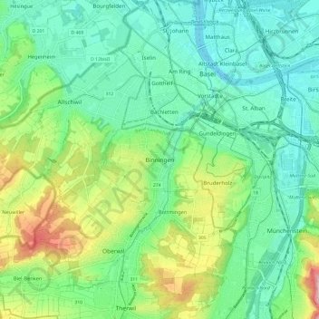
Name: Binningen topographic map, elevation, terrain.
Location: Binningen, Bezirk Arlesheim, Basel-Landschaft, 4102, Suíça (47.49656 7.53008 47.57656 7.61008)
Average elevation: 309 m
Minimum elevation: 243 m
Maximum elevation: 474 m
Other topographic maps
Click on a map to view its topography, its elevation and its terrain.
Geiser
Suíça > Basel-Landschaft > Bezirk Arlesheim > Allschwil
Geiser, Allschwil, Bezirk Arlesheim, Basel-Landschaft, 4123, Suíça
Average elevation: 355 m