
Make a donation
Rudbaxton topographic map
Click on the map to display elevation.
Make a donation
About this map
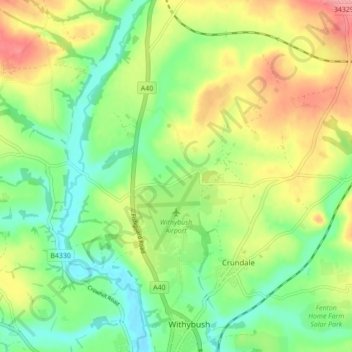
Name: Rudbaxton topographic map, elevation, terrain.
Location: Rudbaxton, Pembrokeshire, Wales, United Kingdom (51.81321 -4.99012 51.86395 -4.90336)
Average elevation: 44 m
Minimum elevation: 5 m
Maximum elevation: 100 m
Make a donation
Other topographic maps
Click on a map to view its topography, its elevation and its terrain.
Make a donation
Make a donation
Make a donation
Make a donation
Make a donation
Make a donation
Make a donation
Make a donation
Make a donation
Make a donation
Make a donation
Make a donation
Preseli Mountains
United Kingdom > Wales > Pembrokeshire > Puncheston
Samuel Lewis's A Topographical Dictionary of Wales published in 1833 said of Maenclochog parish.
Average elevation: 217 m
Make a donation
Make a donation
Make a donation
Make a donation
Make a donation
Caldey Island
United Kingdom > Wales > Pembrokeshire
Caldey Island is about 1.5 miles (2.4 km) long and 1 mile (1.6 km) in width at its widest. It has an area of 538 acres (2.18 km2) and its highest elevation is 197 feet (60 m). The island lies in Carmarthen Bay on the northern side of the Bristol Channel in the county of Pembrokeshire, a little over 2.5 miles…
Average elevation: 5 m
Make a donation
Make a donation
Make a donation
Square and Compass
United Kingdom > Wales > Pembrokeshire > St Davids > Square and Compass
Average elevation: 91 m
Make a donation
Make a donation
Walton West
United Kingdom > Wales > Pembrokeshire > Broad Haven > Walton West
Average elevation: 45 m
Make a donation
Make a donation
Make a donation