
Thank you for supporting this site ❤️
Make a donation
Make a donation
Kalamazoo River topographic map
Click on the map to display elevation.
Thank you for supporting this site ❤️
Make a donation
Make a donation
About this map
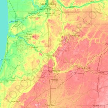
Name: Kalamazoo River topographic map, elevation, terrain.
Location: Kalamazoo River, Michigan, United States (42.24085 -86.29829 42.68799 -84.74853)
Average elevation: 244 m
Minimum elevation: 173 m
Maximum elevation: 345 m
Thank you for supporting this site ❤️
Make a donation
Make a donation
Other topographic maps
Click on a map to view its topography, its elevation and its terrain.