
Thank you for supporting this site ❤️
Make a donation
Make a donation
Kembaran topographic map
Click on the map to display elevation.
Thank you for supporting this site ❤️
Make a donation
Make a donation
About this map
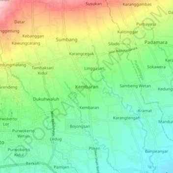
Name: Kembaran topographic map, elevation, terrain.
Location: Kembaran, Banyumas, Central Java, Java, 53182, Indonesia (-7.44217 109.24594 -7.36217 109.32594)
Average elevation: 103 m
Minimum elevation: 28 m
Maximum elevation: 250 m
Thank you for supporting this site ❤️
Make a donation
Make a donation
Other topographic maps
Click on a map to view its topography, its elevation and its terrain.