
Make a donation
Gmunden topographic map
Click on the map to display elevation.
Make a donation
Gmunden
Gmunden covers an area of 63.49 square kilometres (24.51 sq mi) and has a median elevation of 425 metres (1,394 ft). It is situated next to the lake Traunsee on the Traun River and is surrounded by high mountains, including the Traunstein (5,446 feet; 1,660 m), the Erlakogel (5,150 feet; 1,570 m), the Wilder Kogel (6,860 feet; 2,090 m) and the Höllengebirge.
Make a donation
About this map
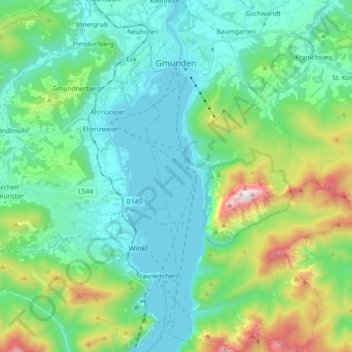
Name: Gmunden topographic map, elevation, terrain.
Location: Gmunden, Bezirk Gmunden, Upper Austria, 4810, Austria (47.81858 13.77477 47.94020 13.90030)
Average elevation: 692 m
Minimum elevation: 414 m
Maximum elevation: 1,645 m
Make a donation
Other topographic maps
Click on a map to view its topography, its elevation and its terrain.
Hoher Dachstein
Austria > Upper Austria > Bezirk Gmunden > Gosau
The Dachstein massif covers an area of around 600 square kilometres (230 sq mi) with dozens of peaks above 2,500 m, the highest of which are in the southern and southwestern areas. The main summit of the Hoher Dachstein is at an elevation of 2,997 metres (9,833 ft). Seen from the north, the Dachstein massif is…
Average elevation: 2,341 m
Make a donation
Predigstuhl
Austria > Upper Austria > Bezirk Gmunden > Bad Goisern am Hallstättersee
Average elevation: 921 m
Bad Goisern
Austria > Upper Austria > Bezirk Gmunden > Bad Goisern am Hallstättersee > Bad Goisern
Average elevation: 644 m
Make a donation
Make a donation