
Thank you for supporting this site ❤️
Make a donation
Make a donation
Enna topographic map
Click on the map to display elevation.
Thank you for supporting this site ❤️
Make a donation
Make a donation
About this map
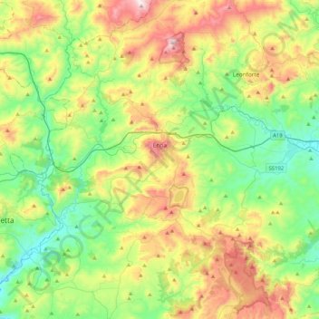
Name: Enna topographic map, elevation, terrain.
Location: Enna, Sicily, 94100, Italy (37.42427 14.08683 37.67894 14.49933)
Average elevation: 545 m
Minimum elevation: 222 m
Maximum elevation: 1,161 m
Thank you for supporting this site ❤️
Make a donation
Make a donation
Other topographic maps
Click on a map to view its topography, its elevation and its terrain.