
El Mehara topographic map
Interactive map
Click on the map to display elevation.
About this map
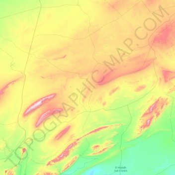
Name: El Mehara topographic map, elevation, terrain.
Location: El Mehara, daïra Chellala, El Bayadh, 32002, Algérie (32.86875 -0.01786 33.67074 0.92339)
Average elevation: 1,194 m
Minimum elevation: 855 m
Maximum elevation: 1,775 m
Other topographic maps
Click on a map to view its topography, its elevation and its terrain.
Chellala
Algérie > El Bayadh > daïra Chellala
Chellala, daïra Chellala, El Bayadh, Algérie
Average elevation: 1,156 m
Chellala Dahrania
Algérie > El Bayadh > daïra Chellala > Chellala
Chellala Dahrania, Chellala, daïra Chellala, El Bayadh, Algérie
Average elevation: 1,132 m