
Make a donation
Green Township topographic map
Click on the map to display elevation.
Make a donation
About this map
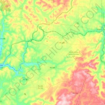
Name: Green Township topographic map, elevation, terrain.
Location: Green Township, Indiana County, Pennsylvania, United States (40.63564 -79.01880 40.74682 -78.80886)
Average elevation: 495 m
Minimum elevation: 372 m
Maximum elevation: 648 m
Make a donation
Other topographic maps
Click on a map to view its topography, its elevation and its terrain.
Claypoole Heights
United States > Pennsylvania > Indiana County > White Township
Average elevation: 421 m
Rochester Mills
United States > Pennsylvania > Indiana County > Grant Township
Average elevation: 462 m
Make a donation
Marchand
United States > Pennsylvania > Indiana County > North Mahoning Township
Average elevation: 462 m
Make a donation
Dilltown
United States > Pennsylvania > Indiana County > East Wheatfield Township
Average elevation: 474 m
Clarksburg
United States > Pennsylvania > Indiana County > Conemaugh Township
Average elevation: 339 m
Make a donation
Brush Valley
United States > Pennsylvania > Indiana County > Brush Valley Township
Average elevation: 446 m
Make a donation
Fairfield Heights
United States > Pennsylvania > Indiana County > Burrell Township
Average elevation: 396 m
Make a donation
Hillsdale
United States > Pennsylvania > Indiana County > Montgomery Township
Average elevation: 511 m
Make a donation