
Make a donation
Matsudo topographic map
Click on the map to display elevation.
Make a donation
Matsudo
Matsudo is located in the far northwestern corner of Chiba Prefecture, about 20 to 30 kilometers from the prefectural capital at Chiba and 10 to 20 kilometers from downtown Tokyo. The western border of the city is the Edo River, which flows from north to south, and most of the city is on an alluvial plain with an elevation of only around four meters above sea level, with the eastern end rising to 20 to 30 meters on the Shimōsa Plateau. The city has the approximate dimensions of 11.4 kilometers from east-to-west and 11.6 kilometers from north-to-south.
Make a donation
About this map
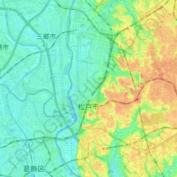
Name: Matsudo topographic map, elevation, terrain.
Location: Matsudo, Chiba Prefecture, Japan (35.74672 139.87939 35.84977 140.00136)
Average elevation: 13 m
Minimum elevation: -7 m
Maximum elevation: 37 m
Make a donation
Other topographic maps
Click on a map to view its topography, its elevation and its terrain.
Mt. Fuji
Japan > Sunto County > Oyama
Mount Fuji (富士山, Fujisan, Japanese: [ɸɯꜜ(d)ʑisaɴ] ) is an active stratovolcano located on the Japanese island of Honshu, with a summit elevation of 3,776.24 m (12,389 ft 3 in). It is the tallest mountain in Japan, the second-highest volcano located on an island in Asia (after Mount Kerinci on the…
Average elevation: 3,261 m
Make a donation