
Thank you for supporting this site ❤️
Make a donation
Make a donation
Breitenbrunn topographic map
Click on the map to display elevation.
Thank you for supporting this site ❤️
Make a donation
Make a donation
About this map
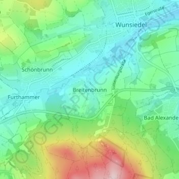
Name: Breitenbrunn topographic map, elevation, terrain.
Average elevation: 607 m
Minimum elevation: 525 m
Maximum elevation: 823 m
Thank you for supporting this site ❤️
Make a donation
Make a donation
Other topographic maps
Click on a map to view its topography, its elevation and its terrain.
Kapple
Deutschland > Bayern > Landkreis Wunsiedel im Fichtelgebirge > Wunsiedel > Schönbrunn > Göringsreuth
Average elevation: 587 m