
Thank you for supporting this site ❤️
Make a donation
Make a donation
Nete topographic map
Click on the map to display elevation.
Thank you for supporting this site ❤️
Make a donation
Make a donation
About this map
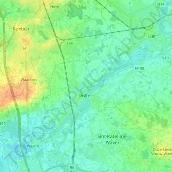
Name: Nete topographic map, elevation, terrain.
Location: Nete, Duffel, Mechelen, Antwerpen, België (51.07158 4.41945 51.13115 4.58212)
Average elevation: 9 m
Minimum elevation: -1 m
Maximum elevation: 32 m
Thank you for supporting this site ❤️
Make a donation
Make a donation
Other topographic maps
Click on a map to view its topography, its elevation and its terrain.