
La Chaumerette topographic map
Interactive map
Click on the map to display elevation.
About this map
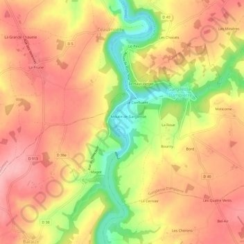
Name: La Chaumerette topographic map, elevation, terrain.
Average elevation: 212 m
Minimum elevation: 122 m
Maximum elevation: 267 m
Other topographic maps
Click on a map to view its topography, its elevation and its terrain.
Dampierre
France > Centre-Val de Loire > Indre > Gargilesse-Dampierre
Dampierre, Gargilesse-Dampierre, Châteauroux, Indre, Centre-Val de Loire, France métropolitaine, 36190, France
Average elevation: 226 m
Moulin de Gargilesse
France > Centre-Val de Loire > Indre > Gargilesse-Dampierre > Moulin de Gargilesse
Moulin de Gargilesse, Gargilesse-Dampierre, Châteauroux, Indre, Centre-Val de Loire, France métropolitaine, 36190, France
Average elevation: 211 m