
Thank you for supporting this site ❤️
Make a donation
Make a donation
Rosarito topographic map
Click on the map to display elevation.
Thank you for supporting this site ❤️
Make a donation
Make a donation
Rosarito
Playas de Rosarito lies on the coast of the Pacific Ocean on the North Baja California Peninsula. The city is positioned between the foothills of the Peninsular Ranges and the ocean. It maintains a relatively uniform topography and displays few variances in terrain.
Thank you for supporting this site ❤️
Make a donation
Make a donation
About this map
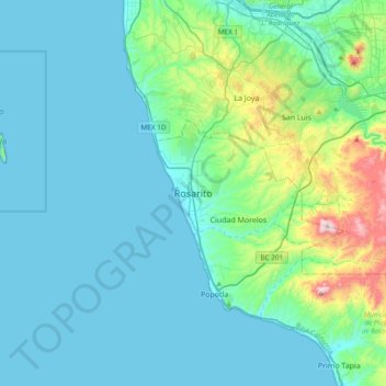
Name: Rosarito topographic map, elevation, terrain.
Average elevation: 103 m
Minimum elevation: 0 m
Maximum elevation: 724 m
Thank you for supporting this site ❤️
Make a donation
Make a donation