
Make a donation
Positano topographic map
Click on the map to display elevation.
Make a donation
Positano
Positano’s physical geography is defined by its steep, cliffside setting along the Amalfi Coast, where pastel-colored buildings appear to cascade down toward the Tyrrhenian Sea. The town is built on rugged limestone slopes of the Lattari Mountains, creating a “vertical village” layout with narrow stairways and terraced homes. Its terrain rises quickly from sea level to elevations over 400 meters, limiting expansion but enhancing its dramatic beauty. The area features Mediterranean vegetation like olive trees, lemon groves, and pines, thriving under a warm, dry summer climate and mild winters. Beaches such as Spiaggia Grande and Fornillo nestle in coves at the base of steep cliffs, accessible only by footpaths or boat.
Make a donation
About this map
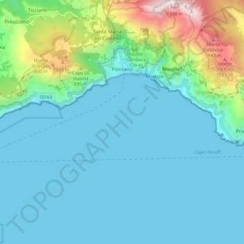
Name: Positano topographic map, elevation, terrain.
Location: Positano, Salerno, Campania, 84017, Italy (40.57919 14.42830 40.64818 14.51792)
Average elevation: 244 m
Minimum elevation: 0 m
Maximum elevation: 1,400 m
Make a donation
Other topographic maps
Click on a map to view its topography, its elevation and its terrain.
Make a donation
Make a donation
Pontecagnano Faiano
Italy > Campania > Salerno > Pontecagnano Faiano > Pontecagnano Faiano
Average elevation: 79 m
Make a donation