
Make a donation
Viehhofen topographic map
Click on the map to display elevation.
Make a donation
Viehhofen
The town lies at an elevation of 856 m above sea level in the middle of Glemmtal Valley, through which flows the River Saalach. The valley's main town is our western neighbor, Saalbach-Hinterglemm. To the east, at the entrance to the valley, you will find the village of Maishofen.
Make a donation
About this map
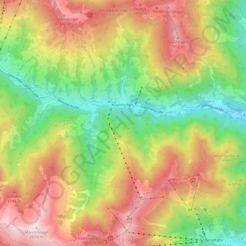
Name: Viehhofen topographic map, elevation, terrain.
Location: Viehhofen, Bezirk Zell am See, Salzburg, 5752, Austria (47.32486 12.67016 47.39696 12.77287)
Average elevation: 1,376 m
Minimum elevation: 780 m
Maximum elevation: 2,065 m
Make a donation
Other topographic maps
Click on a map to view its topography, its elevation and its terrain.
Sankt Martin bei Lofer
Austria > Salzburg > Bezirk Zell am See > Gemeinde Sankt Martin bei Lofer
Average elevation: 913 m
Make a donation
Großvenediger
Austria > Salzburg > Bezirk Zell am See > Neukirchen am Großvenediger
Average elevation: 3,179 m
Make a donation
Großes Wiesbachhorn
Austria > Salzburg > Bezirk Zell am See > Fusch an der Großglocknerstraße
Average elevation: 2,879 m
Make a donation
Schmalenbergham
Austria > Salzburg > Bezirk Zell am See > Saalfelden am Steinernen Meer > Thor
Average elevation: 784 m
Make a donation
Königsleiten
Austria > Salzburg > Bezirk Zell am See > Gemeinde Wald im Pinzgau
Average elevation: 1,703 m
Hohlwegen
Austria > Salzburg > Bezirk Zell am See > Saalfelden am Steinernen Meer
Average elevation: 1,106 m
Make a donation
Make a donation
Wald im Pinzgau
Austria > Salzburg > Bezirk Zell am See > Gemeinde Wald im Pinzgau
Average elevation: 1,163 m
Make a donation
Obersulzbachkees
Austria > Salzburg > Bezirk Zell am See > Marktgemeinde Neukirchen am Großvenediger
Average elevation: 2,757 m