
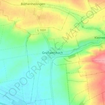
Großwelsbach topographic map
Interactive map
Click on the map to display elevation.
About this map
Name: Großwelsbach topographic map, elevation, terrain.
Average elevation: 211 m
Minimum elevation: 174 m
Maximum elevation: 270 m
Other topographic maps
Click on a map to view its topography, its elevation and its terrain.
Merxleben
Deutschland > Thüringen > Unstrut-Hainich-Kreis > Bad Langensalza
Merxleben, Bad Langensalza, Unstrut-Hainich-Kreis, Thüringen, 99947, Deutschland
Average elevation: 194 m
Wiegleben
Deutschland > Thüringen > Unstrut-Hainich-Kreis > Bad Langensalza
Wiegleben, Bad Langensalza, Unstrut-Hainich-Kreis, Thüringen, 99947, Deutschland
Average elevation: 323 m
Thamsbrück
Deutschland > Thüringen > Unstrut-Hainich-Kreis > Bad Langensalza
Thamsbrück, Bad Langensalza, Unstrut-Hainich-Kreis, Thüringen, 99947, Deutschland
Average elevation: 189 m