
Isla Dring topographic map
Interactive map
Click on the map to display elevation.
About this map
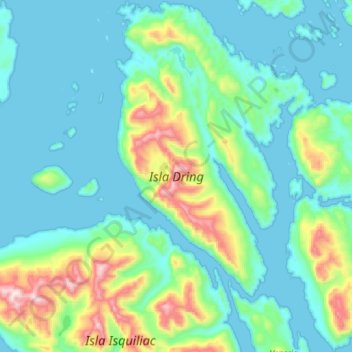
Name: Isla Dring topographic map, elevation, terrain.
Average elevation: 161 m
Minimum elevation: -1 m
Maximum elevation: 886 m
Other topographic maps
Click on a map to view its topography, its elevation and its terrain.
Canal Moraleda
Chile > Región Aysén del General Carlos Ibáñez del Campo > Aysén > Estero Copa
Canal Moraleda, Manuel Rodríguez, Estero Copa, Aysén, Provincia de Aysén, Región Aysén del General Carlos Ibáñez del Campo, Chile
Average elevation: 276 m
Isla Kent
Chile > Región Aysén del General Carlos Ibáñez del Campo > Aysén
Isla Kent, Aysén, Provincia de Aysén, Región Aysén del General Carlos Ibáñez del Campo, Chile
Average elevation: 53 m
Reserva Nacional Las Guaitecas
Chile > Región Aysén del General Carlos Ibáñez del Campo > Aysén
Reserva Nacional Las Guaitecas, Aysén, Provincia de Aysén, Región Aysén del General Carlos Ibáñez del Campo, Chile
Average elevation: 155 m
Isla Nalcayec
Chile > Región Aysén del General Carlos Ibáñez del Campo > Aysén
Isla Nalcayec, Aysén, Provincia de Aysén, Región Aysén del General Carlos Ibáñez del Campo, Chile
Average elevation: 241 m
Península de Taitao
Chile > Región Aysén del General Carlos Ibáñez del Campo > Aysén
Península de Taitao, Aysén, Provincia de Aysén, Región Aysén del General Carlos Ibáñez del Campo, Chile
Average elevation: 616 m
Isla Quillín
Chile > Región Aysén del General Carlos Ibáñez del Campo > Aysén
Isla Quillín, Aysén, Provincia de Aysén, Región Aysén del General Carlos Ibáñez del Campo, Chile
Average elevation: 4 m
Monte San Valentín
Chile > Región Aysén del General Carlos Ibáñez del Campo > Aysén
Monte San Valentín, Aysén, Provincia de Aysén, Región Aysén del General Carlos Ibáñez del Campo, Chile
Average elevation: 3,353 m
Lago Presidente Ríos
Chile > Región Aysén del General Carlos Ibáñez del Campo > Aysén
Lago Presidente Ríos, Aysén, Provincia de Aysén, Región Aysén del General Carlos Ibáñez del Campo, Chile
Average elevation: 224 m
Isla Isquiliac
Chile > Región Aysén del General Carlos Ibáñez del Campo > Aysén
Isla Isquiliac, Aysén, Provincia de Aysén, Región Aysén del General Carlos Ibáñez del Campo, Chile
Average elevation: 167 m
Isla Melchor
Chile > Región Aysén del General Carlos Ibáñez del Campo > Aysén
Isla Melchor, Aysén, Provincia de Aysén, Región Aysén del General Carlos Ibáñez del Campo, Chile
Average elevation: 179 m
Isla Clemente
Chile > Región Aysén del General Carlos Ibáñez del Campo > Aysén
Isla Clemente, Aysén, Provincia de Aysén, Región Aysén del General Carlos Ibáñez del Campo, Chile
Average elevation: 144 m
Isla Quemada
Chile > Región Aysén del General Carlos Ibáñez del Campo > Aysén
Isla Quemada, Aysén, Provincia de Aysén, Región Aysén del General Carlos Ibáñez del Campo, Chile
Average elevation: 165 m
Glaciar San Quintín
Chile > Región Aysén del General Carlos Ibáñez del Campo > Aysén
Glaciar San Quintín, Aysén, Provincia de Aysén, Región Aysén del General Carlos Ibáñez del Campo, Chile
Average elevation: 526 m
Isla Garrido
Chile > Región Aysén del General Carlos Ibáñez del Campo > Aysén
Isla Garrido, Aysén, Provincia de Aysén, Región Aysén del General Carlos Ibáñez del Campo, Chile
Average elevation: 157 m
Lago Yulton
Chile > Región Aysén del General Carlos Ibáñez del Campo > Aysén
Lago Yulton, Aysén, Provincia de Aysén, Región Aysén del General Carlos Ibáñez del Campo, Chile
Average elevation: 676 m
Isla Luz
Chile > Región Aysén del General Carlos Ibáñez del Campo > Aysén
Isla Luz, Aysén, Provincia de Aysén, Región Aysén del General Carlos Ibáñez del Campo, Chile
Average elevation: 135 m
Isla Rivero
Chile > Región Aysén del General Carlos Ibáñez del Campo > Aysén
Isla Rivero, Aysén, Provincia de Aysén, Región Aysén del General Carlos Ibáñez del Campo, Chile
Average elevation: 159 m
Isla Salas
Chile > Región Aysén del General Carlos Ibáñez del Campo > Aysén
Isla Salas, Aysén, Provincia de Aysén, Región Aysén del General Carlos Ibáñez del Campo, Chile
Average elevation: 144 m