
Thank you for supporting this site ❤️
Make a donation
Make a donation
Xhendelesse topographic map
Click on the map to display elevation.
Thank you for supporting this site ❤️
Make a donation
Make a donation
About this map
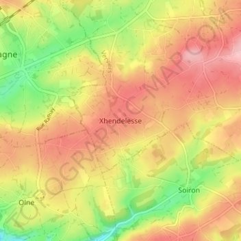
Name: Xhendelesse topographic map, elevation, terrain.
Location: Xhendelesse, Herve, Verviers, Liège, Wallonie, 4650, Belgique (50.58370 5.75265 50.62370 5.79265)
Average elevation: 242 m
Minimum elevation: 161 m
Maximum elevation: 304 m
Thank you for supporting this site ❤️
Make a donation
Make a donation
Other topographic maps
Click on a map to view its topography, its elevation and its terrain.
Charneux
Belgique > Liège > Verviers > Herve
Le village se situe à une altitude moyenne de 230 mètres. Il a une superficie de 1443 hectares, et comprend les hameaux et dépendances suivants : Renouprez, Warrimont, Wadeleux, Val-Dieu, Neuf-Moulin, Larbuisson, Bouxhmont, Asse, Cerfontaine, , Champiomont, Privot, Fastré, Sironval, Faweux, Try, Vivier,…
Average elevation: 225 m
Thank you for supporting this site ❤️
Make a donation
Make a donation
Thank you for supporting this site ❤️
Make a donation
Make a donation