
Königshofen topographic map
Interactive map
Click on the map to display elevation.
About this map
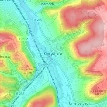
Name: Königshofen topographic map, elevation, terrain.
Average elevation: 262 m
Minimum elevation: 185 m
Maximum elevation: 380 m
Other topographic maps
Click on a map to view its topography, its elevation and its terrain.
Unterbalbach
Deutschland > Baden-Württemberg > Main-Tauber-Kreis > Lauda-Königshofen > Unterbalbach
Unterbalbach, Lauda-Königshofen, Main-Tauber-Kreis, Baden-Württemberg, 97922, Deutschland
Average elevation: 272 m
Kehlberg
Deutschland > Baden-Württemberg > Main-Tauber-Kreis > Lauda-Königshofen
Kehlberg, Lauda-Königshofen, Main-Tauber-Kreis, Baden-Württemberg, 97947, Deutschland
Average elevation: 260 m