
Readlyn topographic map
Interactive map
Click on the map to display elevation.
About this map
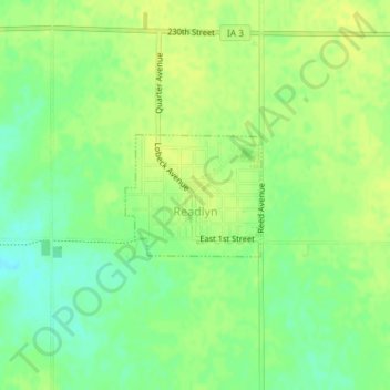
Name: Readlyn topographic map, elevation, terrain.
Location: Readlyn, Bremer County, Iowa, United States (42.69935 -92.23183 42.70781 -92.21898)
Average elevation: 315 m
Minimum elevation: 303 m
Maximum elevation: 322 m
Other topographic maps
Click on a map to view its topography, its elevation and its terrain.
Frederika
United States > Iowa > Bremer County
Frederika, Bremer County, Iowa, 50631, United States
Average elevation: 318 m
Janesville
United States > Iowa > Bremer County
Janesville, Bremer County, Iowa, United States
Average elevation: 274 m
Plainfield
United States > Iowa > Bremer County
Plainfield, Bremer County, Iowa, United States
Average elevation: 291 m
Tripoli
United States > Iowa > Bremer County
Tripoli, Bremer County, Iowa, United States
Average elevation: 318 m
Sumner
United States > Iowa > Bremer County
Sumner, Bremer County, Iowa, United States
Average elevation: 329 m
Waverly
United States > Iowa > Bremer County
Waverly, Bremer County, Iowa, 50677, United States
Average elevation: 293 m
Denver
United States > Iowa > Bremer County
Denver, Bremer County, Iowa, 50622, United States
Average elevation: 298 m