
Make a donation
Fayette City topographic map
Click on the map to display elevation.
Make a donation
Fayette City
Fayette City's low elevation and location along the Monongahela River make it susceptible to flooding after heavy rains. Lamb Lick Run and Downers Run enter the Monongahela within the borough's boundaries.
Make a donation
About this map
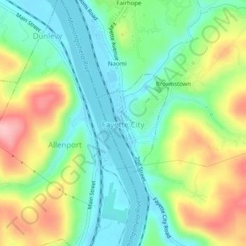
Name: Fayette City topographic map, elevation, terrain.
Location: Fayette City, Fayette County, Pennsylvania, United States (40.09501 -79.84422 40.10589 -79.83409)
Average elevation: 285 m
Minimum elevation: 230 m
Maximum elevation: 381 m
Make a donation
Other topographic maps
Click on a map to view its topography, its elevation and its terrain.
South Uniontown
United States > Pennsylvania > Fayette County > South Union Township
Average elevation: 337 m
New Meadow Run Bruderhof
United States > Pennsylvania > Fayette County > Wharton Township
Average elevation: 583 m
West Leisenring
United States > Pennsylvania > Fayette County > Dunbar Township
Average elevation: 335 m
Make a donation
Mount Braddock
United States > Pennsylvania > Fayette County > North Union Township
Average elevation: 397 m
Merrittstown
United States > Pennsylvania > Fayette County > Redstone Township
Average elevation: 318 m
Make a donation
McClellandtown
United States > Pennsylvania > Fayette County > German Township
Average elevation: 338 m
Lake Lynn
United States > Pennsylvania > Fayette County > Springhill Township
Average elevation: 324 m
Make a donation
La Belle
United States > Pennsylvania > Fayette County > Luzerne Township > Luzerne
Average elevation: 296 m
Keisterville
United States > Pennsylvania > Fayette County > Menallen Township
Average elevation: 347 m
Indian Head
United States > Pennsylvania > Fayette County > Saltlick Township
Average elevation: 512 m
Make a donation
East Millsboro
United States > Pennsylvania > Fayette County > Luzerne Township
Average elevation: 310 m
Make a donation
Lemont Furnace
United States > Pennsylvania > Fayette County > North Union Township
Average elevation: 372 m
Make a donation
Grindstone
United States > Pennsylvania > Fayette County > Jefferson Township
Average elevation: 313 m
Make a donation
Trotter
United States > Pennsylvania > Fayette County > Dunbar Township > Trotter
Average elevation: 322 m
Tower Hill Number Two
United States > Pennsylvania > Fayette County > Luzerne Township > Tower Hill Number Two
Average elevation: 325 m
Jumonville
United States > Pennsylvania > Fayette County > North Union Township > Jumonville
Average elevation: 613 m
Make a donation
Mill Run
United States > Pennsylvania > Fayette County > Springfield Township
Average elevation: 482 m
Buena Vista
United States > Pennsylvania > Fayette County > Franklin Township
Average elevation: 384 m
Make a donation