
San Jacinto topographic map
Interactive map
Click on the map to display elevation.
About this map
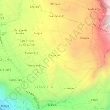
Name: San Jacinto topographic map, elevation, terrain.
Average elevation: 2,855 m
Minimum elevation: 2,249 m
Maximum elevation: 3,433 m
Other topographic maps
Click on a map to view its topography, its elevation and its terrain.
El Censo
Ecuador > Tungurahua > Santiago de Pillaro > San Pedro de Cruzñan
El Censo, San Pedro de Cruzñan, San Miguelito, Santiago de Pillaro, Tungurahua, 180503, Ecuador
Average elevation: 2,742 m