
Thank you for supporting this site ❤️
Make a donation
Make a donation
Drum topographic map
Click on the map to display elevation.
Thank you for supporting this site ❤️
Make a donation
Make a donation
About this map
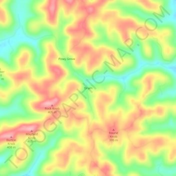
Name: Drum topographic map, elevation, terrain.
Location: Drum, Pulaski County, Kentucky, United States (37.07369 -84.50022 37.11369 -84.46022)
Average elevation: 332 m
Minimum elevation: 261 m
Maximum elevation: 398 m
Thank you for supporting this site ❤️
Make a donation
Make a donation
Other topographic maps
Click on a map to view its topography, its elevation and its terrain.
Somerset
United States > Kentucky > Pulaski County
Somerset is located at 37°4′59″N 84°36′34″W / 37.08306°N 84.60944°W / 37.08306; -84.60944 (37.082966, −84.609387), and the downtown (central) part of the city is at an elevation of 974 feet above sea level. The city is located at the eastern end of Kentucky's Mississippian Plateau (or…
Average elevation: 295 m