
Thank you for supporting this site ❤️
Make a donation
Make a donation
Valley Falls topographic map
Click on the map to display elevation.
Thank you for supporting this site ❤️
Make a donation
Make a donation
About this map
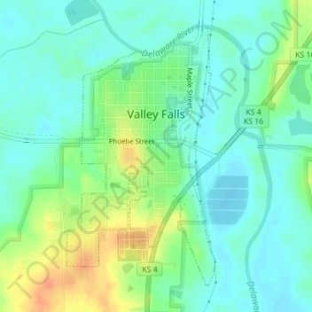
Name: Valley Falls topographic map, elevation, terrain.
Location: Valley Falls, Jefferson County, Kansas, United States (39.32837 -95.46971 39.35079 -95.45317)
Average elevation: 288 m
Minimum elevation: 274 m
Maximum elevation: 316 m
Thank you for supporting this site ❤️
Make a donation
Make a donation
Other topographic maps
Click on a map to view its topography, its elevation and its terrain.
Valley Falls
United States > Kansas > Jefferson County > Valley Falls > Valley Falls
Average elevation: 296 m