
Embilipitiya topographic map
Interactive map
Click on the map to display elevation.
About this map
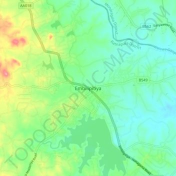
Name: Embilipitiya topographic map, elevation, terrain.
Average elevation: 68 m
Minimum elevation: 36 m
Maximum elevation: 144 m
Other topographic maps
Click on a map to view its topography, its elevation and its terrain.
Balangoda
Sri Lanka > Sabaragamuwa Province
Balangoda, Ratnapura District, Sabaragamuwa Province, 12345, Sri Lanka
Average elevation: 572 m
Sinharaja Forest Reserve
Sri Lanka > Sabaragamuwa Province > Pothupitiya
Sinharaja Forest Reserve, pothupitiya-Dungahamulla para, Pothupitiya, Ratnapura District, Sabaragamuwa Province, Sri Lanka
Average elevation: 377 m