
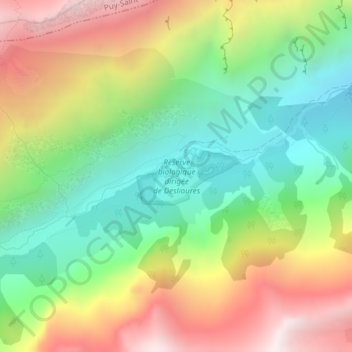
Réserve biologique dirigée de Deslioures topographic map
Interactive map
Click on the map to display elevation.
About this map
Name: Réserve biologique dirigée de Deslioures topographic map, elevation, terrain.
Average elevation: 2,002 m
Minimum elevation: 1,476 m
Maximum elevation: 2,717 m
Other topographic maps
Click on a map to view its topography, its elevation and its terrain.
Les Prés
France > Provence-Alpes-Côte d'Azur > Hautes-Alpes > Puy-Saint-Vincent
Les Prés, Puy-Saint-Vincent, Briançon, Hautes-Alpes, Provence-Alpes-Côte d'Azur, France métropolitaine, 05290, France
Average elevation: 1,511 m
Lac des Hermes
France > Provence-Alpes-Côte d'Azur > Hautes-Alpes > Puy-Saint-Vincent
Lac des Hermes, Puy-Saint-Vincent, Briançon, Hautes-Alpes, Provence-Alpes-Côte d'Azur, France métropolitaine, 05290, France
Average elevation: 1,816 m
Les Alberts
France > Provence-Alpes-Côte d'Azur > Hautes-Alpes > Puy-Saint-Vincent
Les Alberts, Puy-Saint-Vincent, Briançon, Hautes-Alpes, Provence-Alpes-Côte d'Azur, France métropolitaine, 05290, France
Average elevation: 1,489 m
Prey d'Aval
France > Provence-Alpes-Côte d'Azur > Hautes-Alpes > Puy-Saint-Vincent
Prey d'Aval, Puy-Saint-Vincent, Briançon, Hautes-Alpes, Provence-Alpes-Côte d'Azur, France métropolitaine, 05290, France
Average elevation: 1,577 m
Station 1800
France > Provence-Alpes-Côte d'Azur > Hautes-Alpes > Puy-Saint-Vincent
Station 1800, Puy-Saint-Vincent, Briançon, Hautes-Alpes, Provence-Alpes-Côte d'Azur, France métropolitaine, 05290, France
Average elevation: 1,768 m
Le Puy
France > Provence-Alpes-Côte d'Azur > Hautes-Alpes > Puy-Saint-Vincent
Le Puy, Puy-Saint-Vincent, Briançon, Hautes-Alpes, Provence-Alpes-Côte d'Azur, France métropolitaine, 05290, France
Average elevation: 1,509 m