
Thank you for supporting this site ❤️
Make a donation
Make a donation
Tanakpur topographic map
Click on the map to display elevation.
Thank you for supporting this site ❤️
Make a donation
Make a donation
Tanakpur
Tanakpur is located at 29°05′N 80°07′E / 29.08°N 80.12°E / 29.08; 80.12. It has an average elevation of 255 metres (837 feet).
Thank you for supporting this site ❤️
Make a donation
Make a donation
About this map
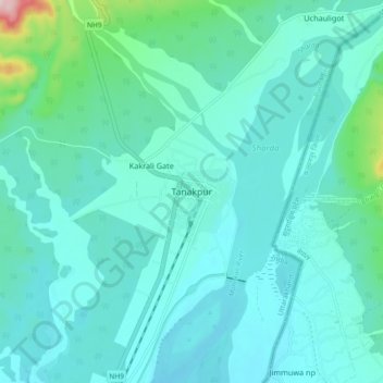
Name: Tanakpur topographic map, elevation, terrain.
Average elevation: 270 m
Minimum elevation: 225 m
Maximum elevation: 564 m
Thank you for supporting this site ❤️
Make a donation
Make a donation