
Hassi Fedoul topographic map
Interactive map
Click on the map to display elevation.
About this map
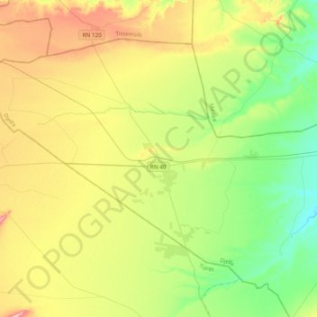
Name: Hassi Fedoul topographic map, elevation, terrain.
Location: Hassi Fedoul, Daïra Sidi Ladjel, Djelfa, Algérie (35.32217 2.01267 35.55874 2.39629)
Average elevation: 798 m
Minimum elevation: 702 m
Maximum elevation: 964 m
Other topographic maps
Click on a map to view its topography, its elevation and its terrain.
Sidi Ladjel
Algérie > Djelfa > Daïra Sidi Ladjel
Sidi Ladjel, Daïra Sidi Ladjel, Djelfa, 17215, Algérie
Average elevation: 740 m